Mount Rainier: Volcano Facts, Risks & Visitor Guide
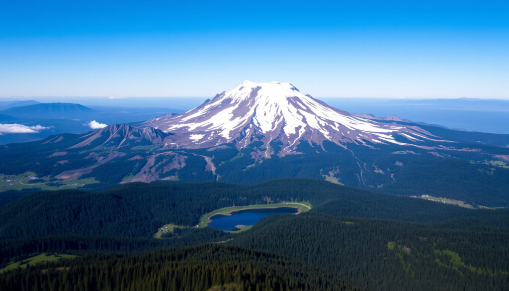
Beneath Mount Rainier’s serene, glacier-draped summit lies one of the most closely watched volcanoes in the United States—a sleeping giant whose primary threat isn’t lava but fast-moving mudflows called lahars that could reach populated areas within an hour. This guide breaks down the volcano’s real risks, its recent history, and what you need to know whether you’re planning a hike or just wondering what all the concern is about.
Elevation: 14,411 ft (4,392 m) ·
Last eruption: Approximately 1,100 years ago ·
Prominence: 13,210 ft (4,026 m) ·
Location: Mount Rainier National Park, Washington, USA ·
Glaciers count: 26 major glaciers
Quick snapshot
- Active stratovolcano in the Cascade Range (USGS, the federal volcano monitoring agency)
- Most glaciated peak in the contiguous U.S. with 26 major glaciers (National Park Service)
- Last major eruption about 1,100 years ago, around 950–1000 CE (USGS)
- Exact year of the last eruption (only approximated via radiocarbon dating) (USGS)
- Probability the next eruption will occur in any specific year (USGS Volcano Notice)
- Precise extent of damage in specific communities during a large lahar (Pierce County emergency management authorities)
- Continuous seismic monitoring since the 1970s (USGS Cascades Volcano Observatory)
- Mount St. Helens’ 1980 eruption renewed regional focus on Cascade volcanoes (USGS)
- A “no-notice” lahar remains a plausible un-triggered scenario (USGS Volcano Notice)
- USGS continues real-time monitoring with seismometers and GPS stations (USGS)
- Pierce County maintains lahar warning sirens and evacuation drills (Pierce County guidance)
- Warmer climate may increase lahar frequency due to glacial melt (Washington State DNR)
Six key facts, one pattern: Mount Rainier’s threat profile is defined not by explosive force but by its massive ice cap and proximity to people.
| Attribute | Value |
|---|---|
| Elevation | 14,411 ft (4,392 m) |
| Prominence | 13,210 ft (4,026 m) |
| Location | Pierce and Lewis Counties, Washington |
| National Park Established | 1899 |
| Last Eruption | Approximately 1,100 years ago (989–1010 CE) |
| Number of Named Glaciers | 26 |
What is so special about Mount Rainier?
Mount Rainier is the most glaciated peak in the contiguous United States, with 26 major glaciers covering about 35 square miles (National Park Service). Its elevation of 14,411 ft makes it the highest volcano in the Cascade Range, and it spawns five major river systems—the Puyallup, Nisqually, Carbon, White, and Cowlitz—that drain into the Puget Sound lowlands.
Beyond its statistics, the park’s subalpine wildflower meadows at Paradise and Sunrise are legendary. In July and August, the slopes explode with lupine, paintbrush, and asters, drawing over 1.5 million visitors annually (NPS visitor data). But those same glaciers that make the landscape beautiful also make the volcano uniquely hazardous: they provide the water that feeds potential lahars.
The implication: this dual identity forces every visitor and resident to treat Rainier with a level of caution unmatched by other U.S. national park peaks.
When was the last time Mount Rainier erupted?
How do scientists know the last eruption date?
- The last confirmed major eruption occurred approximately 1,100 years ago, around 950–1000 CE, dated through radiocarbon analysis of ash layers and buried charcoal (USGS, the federal volcano monitoring agency).
- No written records exist from that period, so the date is an approximation with a margin of error of several decades.
Has there been any recent volcanic activity?
- Minor steam explosions were recorded in the 1840s–1890s, along with increased fumarolic activity (USGS historical notes).
- Today, the USGS Cascades Volcano Observatory monitors the mountain with a network of seismometers, GPS stations, and gas sensors. Fumaroles on the summit continue to emit steam and sulfurous gases, indicating the magma system is still active (USGS monitoring page).
The implication: The volcano is not extinct—it’s in a long dormancy that could end with little warning. The last eruption was not an anomaly but part of a pattern of eruptive episodes separated by centuries.
Who is at risk if Mount Rainier erupts and what would happen?
What is the primary hazard: lava flows or lahars?
The greatest threat is not lava flows but lahars—volcanic mudflows composed of melted ice, rock, and debris that can travel 40–50 mph down river valleys (USGS lahar hazards page). Mount Rainier holds more glacial ice than any other Cascade volcano, meaning even a moderate eruption can mobilize massive volumes of water and sediment.
Which communities are most vulnerable?
- Communities in the Puyallup and Nisqually River valleys, including parts of Orting, Sumner, Puyallup, and even Tacoma, are directly in the path of potential lahars (USGS Volcano Notice).
- The Washington State DNR warns that lahars can reach the closest populated areas within one hour (Washington State DNR guidance).
- Within the park, NPS notes that Longmire, Carbon, and campgrounds at Cougar Rock, Ohanapecosh, and White River are all vulnerable to geologic hazards (National Park Service geohazards page).
What is the current risk assessment?
The USGS ranks Mount Rainier as one of the most dangerous volcanoes in the United States—not because it’s the most eruptive, but because its combination of glacial ice, steep slopes, and proximity to 2.5 million people in the Seattle−Tacoma metro area creates a uniquely high risk profile (USGS risk assessment).
Which is bigger, Mount Rainier or Mount St. Helens?
Three dimensions, one clear winner: Rainier dwarfs St. Helens in height, prominence, and ice volume—but St. Helens has a more violent recent history.
| Metric | Mount Rainier | Mount St. Helens |
|---|---|---|
| Height (summit elevation) | 14,411 ft (4,392 m) | 8,363 ft (2,549 m) – pre-1980 |
| Prominence | 13,210 ft (4,026 m) | 4,605 ft (1,404 m) |
| Glacial ice volume | ~35 sq mi of glacial coverage | ~1 sq mi (mostly gone after 1980) |
| Last major eruption | ~1,100 years ago | May 18, 1980 |
| Primary hazard type | Lahars (mudflows) | Lateral blast, ashfall, pyroclastic flows |
| Closest major city distance | ~35 mi from Tacoma | ~50 mi from Portland |
While Mount St. Helens is historically more active, Mount Rainier’s greater volume of ice and its location just 35 miles from Tacoma amplify its lahar risk to a far larger population. In terms of potential destruction to infrastructure, Rainier’s threat is arguably greater.
The catch: the volcano that hasn’t erupted in a millennium could still cause more damage than the one that blew in 1980.
What can visitors do at Mount Rainier National Park?
How to prepare for a safe and memorable visit
- Check alerts before you go. Visit the NPS geohazards page for current conditions. Lahars can occur without warning, even during eruptions; know the siren system and evacuation routes for your location.
- Pack for all seasons. Weather changes fast. Bring rain gear, layers, sturdy boots, and plenty of water. Glacier travel requires crampons, ice axe, and a rope—never attempt the summit without guided training (NPS climbing guide).
- Choose your trail wisely. The park offers over 260 miles of hiking trails. Popular day hikes include the Skyline Trail at Paradise (5.5 miles, moderate) and the Naches Peak Loop (3.5 miles, easy). For serious hikers, the Wonderland Trail circumvents the mountain over 93 miles (NPS trail descriptions).
- Know the lahar safety basics. If you hear a roaring sound like a freight train, see a rapid rise or drop in water level, or feel prolonged shaking, move immediately to high ground—at least 50 ft (15 m) above the valley floor (NPS safety guidelines). Pierce County also advises evacuating by vehicle or on foot to high ground if warning is issued (Pierce County emergency guidance).
- Time your visit right. Wildflower season peaks July–August. Summer weekends can be crowded; arrive early (before 9 am) to secure parking at Paradise and Sunrise. Fall offers spectacular colors and fewer crowds (NPS seasonal tips).
Visitors who plan ahead and respect the mountain’s dual identity—a stunning outdoor playground and an active volcano—will have the safest and most rewarding experience. That means checking alert systems before the trip and knowing how to react if the ground shakes.
Timeline of Mount Rainier’s Volcanic Activity
- c. 950–1000 CE – Last major eruption (undated, but ash layers and charcoal show this period) (USGS)
- 1840s–1890s – Minor steam explosions and increased fumarolic activity recorded (USGS historical records)
- 1899 – Mount Rainier National Park established (National Park Service)
- 1970s–present – Continuous seismic monitoring by USGS Cascades Volcano Observatory (USGS monitoring page)
- 1980 – Mount St. Helens eruption renews focus on Cascade volcanoes (USGS)
What We Know and What Remains Unclear
Confirmed facts
- Mount Rainier is an active volcano with 26 major glaciers (USGS)
- The last confirmed eruption occurred about 1,100 years ago (USGS)
- Lahars are the most probable risk in a future eruption (USGS)
- USGS monitors the mountain with a network of seismometers and GPS stations (USGS monitoring)
What’s unclear
- Exact date of the last eruption (only approximated via radiocarbon dating) (USGS)
- Probability that the next eruption will occur in 2026 or any specific year (USGS Volcano Notice)
- Extent of damage in specific communities during a large lahar event (Pierce County emergency authorities)
Expert Perspectives on the Lahar Threat
“Mount Rainier has the capacity to produce very large lahars that could reach the Puget Sound lowlands.”
– Dr. Seth Moran, Scientist-in-Charge at the USGS Cascades Volcano Observatory (USGS)
“Mount Rainier’s glaciers, wildflower meadows, and five major rivers make it one of the most unique landscapes in the national park system. But that same glacial cap makes it one of the most hazardous volcanoes in the Cascade Range.”
– National Park Service interpretive sign at Paradise, citing the NPS geohazards program
The key risk is timing: lahars can outrun any car on valley roads. The USGS and Pierce County have installed warning sirens in vulnerable communities, but you may have only minutes to react. That’s why knowing evacuation routes before you need them is critical.
For the millions living and recreating near Mount Rainier, the takeaway isn’t to be scared—it’s to be prepared. The volcano’s long dormancy could end with little warning, and the primary hazard isn’t lava but fast-moving mudflows. Visitors should check alert systems before heading into the park, and residents of river valleys must know their evacuation plans. For Washington state, the choice is clear: treat Rainier with the respect it deserves, or face the consequences of being caught unprepared.
usgs.gov, parkplanning.nps.gov, puyallupwa.gov, komonews.com, youtube.com, facebook.com, usgs.gov
Frequently Asked Questions
Is Mount Rainier the most dangerous volcano in the United States?
The USGS ranks Mount Rainier among the most dangerous because of its glacial ice, steep slopes, and proximity to a large population (USGS). Kīlauea in Hawaiʻi and Mount St. Helens are also highly ranked, but Rainier’s lahar risk to populated areas gives it a unique threat profile.
How can I check current volcanic activity at Mount Rainier?
The USGS Cascades Volcano Observatory provides real-time data on seismicity, ground deformation, and gas emissions at their Mount Rainier monitoring page.
What should I do if a lahar warning is issued?
Move immediately to high ground at least 50 ft (15 m) above the valley floor. If you’re in a vehicle, evacuate perpendicular to the river. Pierce County also advises seeking shelter in a building if ash is falling and you are safe from lahars (Pierce County guidance).
Can you drive to the summit of Mount Rainier?
No. There is no road to the summit. The highest drivable point is Paradise Visitor Center at about 5,400 ft. Reaching the summit requires technical glacier climbing and a guide (NPS climbing information).
Do I need a permit to climb Mount Rainier?
Yes. All summit climbs require a climbing permit from the National Park Service. Reservations are recommended and can be made online. The cost varies by season (NPS climbing permits).
Are there any hot springs on Mount Rainier?
Yes. The Longmire area has small thermal springs, but they are not developed for bathing. The park’s geothermal features are part of the active volcanic system (NPS geothermal information).
What is the best time of year to visit Mount Rainier National Park?
July through September offers the most accessible trails, wildflowers, and reliable weather. Winter visits are popular for snowshoeing and skiing but require avalanche awareness (NPS seasonal guide).
How do Mount Rainier eruptions compare to Mount St. Helens in scale?
Mount Rainier’s eruptions tend to be less explosive than St. Helens’ 1980 blast, but they can produce larger lahars due to the greater ice volume. The 1980 eruption of St. Helens was VEI 5; Rainier’s past eruptions are VEI 3–4 (USGS).
More related posts
 JFK Jr and Carolyn Bessette – Meeting, Secret Wedding and Plane Crash Facts
 Father Figure Lyrics Taylor Swift: Meaning & Analysis
 Seat Booster Seat Age & Law Guide for Ireland
 Ed Helms: Marital Status, ADHD, Office Exit, Obama Connection
 Tom Ellis: Biography, Age, Height, Wife, Children, Net Worth
 Coffee Shops Near Me – Best Apps to Find Open WiFi Spots
 Rob Halford: Personal Life, Sobriety & Marriage
 La Maison du Dragon – Seasons Cast Streaming Guide
